Search results

File:Kerkum 2009b.pdf ...e projects to be carried out and past results found at all the sides where measures were applied during this project. Text is in dutch.(2.07 MB) - 08:50, 6 April 2010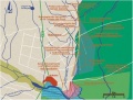
File:Plano Partido.jpg Map of the main measures(508 × 387 (38 KB)) - 14:42, 6 April 2010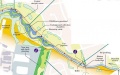
File:Skerne map.JPG Map of measures Skerne(603 × 377 (38 KB)) - 13:50, 30 July 2013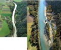
File:Rosenheim before after.JPG Rosenheim before and after the construction of the measures. Modified from Life vein – Upper Drau River (2011)(639 × 525 (74 KB)) - 21:59, 6 August 2013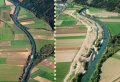
File:Obergottesfeld before after.JPG Obergottesfeld before and after the construction of the measures. Taken from Life vein – Upper Drau River (2011)(739 × 505 (71 KB)) - 22:22, 6 August 2013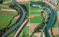
File:Amlach before after.JPG Amlach/St. Peter before and after construction of the measures. Taken from Life vein – Upper Drau River (2011)(818 × 512 (84 KB)) - 22:49, 6 August 2013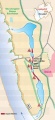
File:Map bislich.JPG Map of planned measures in Bislich-Vahnum. Taken from NABU-Naturschutzstation e.V., Nebenstromrinne(283 × 616 (27 KB)) - 09:24, 7 August 2013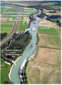
File:D picture1.png Figure 1: Overview restoration measures Kleblach (cp. MANDLER, H., PETUTSCHNIG, W. & SEREINIG, N., 2004)(396 × 540 (593 KB)) - 13:15, 12 February 2014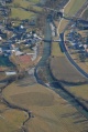
File:E picture1.jpg Figure 1: Overview restoration measures Aich (cp. IHG, 2007)(335 × 500 (71 KB)) - 14:38, 12 February 2014


