Vääräjoki - Niskakoski
Vääräjoki - Niskakoski
Key features of the case study
Vääräjoki is a mid-sized lowland river that has been channelized for flood protection and timer floating. Moroever, water quality is low. Instream habitat conditions have been restored by extensive boulder placement and riffle creation, which had some positive effects on habitat conditions, specific macroinvertebrate traits and increased the number of macrophyte species. Restoration had no effect on fish which already indicated a good ecological status prior to restoration.
Site description
The upper catchment at the restored section is about 835 km² and mean discharge is 9.9 m³/s. In this section, the Vääräjoki is a 4th order stream and is assigned to the fish region brown trout-European bullhead. The river is altogether 107 km long and descends 110 metres from its source to the confluence of the rivers Vääräjoki and Kalajoki.
Drivers and pressures
Altogether 25 km of Vääräjoki were channelized for flood protection and timber floating starting in 1860s and continuing in several occasions until late 1950s. In 1959-1974 lake Evijärvi at mid reach of Vääräjoki was dried for flood protection. Altogether 900 ha of lake area was dried by channelizing the river and by embankments. Especially the activities for flood protection changed the riffle areas considerably: the water retention capacity of the river bed decreased and the heterogeneous flow patterns in riffle habitats disappeared.
In addition, water quality of the river Vääräjoki is affected by human activities in the catchment. 12 % of the catchment area is covered by agricultural uses. Morover, forestry activities, such as land draining by ditches, increase the nutrient load and suspended sediments.
Measures selection
All the rapids in section from 13 km to 29 km of the river mouth have been restored. The extensive works started in the late 1990s and finished in 2006. The stream bottom was rearranged using boulders that had originally been removed from the channel during channelization and placed along stream margins Also gravel beds were created to provide nursery habitat for salmonids. The aim of the restoration was to return the heavily modified river closer to natural hydrological and morphological state and especially enable the breeding and migration of fish. Funding for restoration came from regional water and fisheries boards.
At the time of writing in Autumn 2013, there are plans to continue the restoration works at the other reaches: the restoration plan for upstream reach 35-86 km from river mouth is ready and the restoration work is about to begin. The plan to restore the downstream part of the river (0-13 km from the river mouth) is about to be ready. The riffles in upper part of the river and downstream reaches of the river are yet not restored.
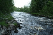
One of the restored rapids in the river Vääräjoki
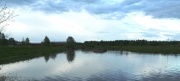
Non-restored section of the Vääräjoki river


Success criteria
The objectives were to return the natural current conditions and morphology of the stream and to enable breeding and migration of salmonid fish.
Ecological response
The overall ecological status of the restored section Vääräjoki has been assessed as moderate in first and second national assessment for WFD.
Periphyton showed good quality in 2003.
Fish were monitored in 2009 and 2012. The monitoring indicated good status of the fish communities and no change to the previous results (EQR = 0,65).
For macrophytes, total species richness was higher in the restored reach. However, the average abundance of bryophytes was slightly lower in the restored reach.
For macroinvertebrates, total density was at the same level in the restored and unrestored sites. However, the density of shredders, that are considered very sensitive to environmental disturbances, was higher in the restored reach.
Riparian and floodplain plant species composition, vegetation age and cover were more natural in the restored compared to the degraded control reach.
The restoration actions were not designed to enhance water quality, which rather showed a negative trend and changed from a moderate (2000-2007) to poor (2006-2012) status. This potentially limited the effect of restoration.
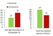
Higher richness of macrophytes in the restored section
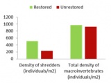
Higher density of shredders in the restored section


Hydromorphological response
The restoration actions created more heterogeneous habitat: there was more variation in substrate and in spatial distribution of substrate in the restored section compared to non-restored site as well as more natural flow patterns, river dynamics and connectivity. However, differences were not statistically significant.
Monitoring before and after implementation of the project
The restored and a still degraded control reach were monitored after restoration (space-for-time substitution). There were no data available prior to restoration for a full BACI monitoring approach (Before-After-Control-Impact).
Socio-economic aspects
A socio-economic study (questionnaire) was conducted at Vääräjoki area as a part of REFOM-project in April 2013 (REFORM deliverable D4.4). The study included a questionnaire on the residents’ general perception of the river, a choice experiment where respondents were able to choose from different restored states or the current situation, and a willingness to pay study (increase of annual municipality tax).
Most of the 67 respondents were residents, some visitors. A large majority (78%) of the local inhabitants visit the river at least several times a year, several even daily (22%). The most common activities were bird or animal watching, angling and walking the dog along the river. A slight majority of the respondents was aware of the restorations and about one third knew about the plans to expand restoration to upstream sections. In the choice experiment most respondents were willing to have a tax increase in order to realize some restorations. From the chosen alternatives that included a raise of municipality tax, 52% choose the alternative with the lowest cost. The average willingness to pay of the chosen alternatives was 29 euro.
In conclusion, the people at Vääräjoki area do visit the river often and appreciate it. They do not only appreciate the river for their own use, but also as a recreational area for other people to enjoy and as a habitat for organisms. Awareness about the river restorations is high and a large majority of the interviewed people perceives the restorations a good idea. Not everyone had a clear view on the effects of the restorations, but most consider improvements in ecological endpoints the main goal. The local people at Vääräjoki area are willing to pay for improved ecological conditions and a more natural view.
Contact person within the organization
Finnish Environmental Institute, Freshwater Centre Jukka Aroviita E-mail: jukka.aroviita@ymparisto.fi
Extra background information
Vääräjoki is part of Kalajoki basin, where several projects targeting to improve the status of inland waters are ongoing:
Mahakala project: When sulfate soils, typical to Kalajoki area, are exposed to oxygen, during soil preparation, ditching or natural land uplift, they might be oxidized and produce acidic runoff. Acidic sulfate soil may cause acidification of waters which might lead to leaking of heavy metals into the waters. The project aims at studying the effects and risks of the acidic soils to the environment and livelihoods. Project Website
Meidän Kalajoki project: This project is a co-operative initiative where local municipalities, officials, scientists, organizations and companies aim to contribute to the water protection in the Kalajoki basin, consult about the use of waters and find new ideas to improve the general appreciation of Kalajoki. The background of the project is the Water Framework Directive goals of good ecological status of waters but also the local aims to improve the scenery, conditions for fish and recreation of the Kalajoki basin. The project is funded by European Regional Development Fund. Project Website
References
Aluehallintovirato. Ympäristöluvat. Lupapäätös Nro 2/12/2. Vääräjoen kalataloudellinen kunnostus, Sievi.
Aronsuu K. & Isid D. 2010. Pohjois-Pohjanmaan jokien hydrologis-morfologiset muutokset sekä mahdolliset hydrologiaan ja morfologiaan vaikuttavat toimenpiteet jokien ekologisen tilan parantamiseksi, www.ymparisto.fi/oulujoen-iijoenvesienhoitoalue
Plug M.C. Comparing the restored and unrestored an Ecosystem Service valuation of the Vääräjoki: A case study for the REFORM project. Amsterdam Free University. Master thesis (unpublished).
Restoration plan for Vääräjoki, unpublished.
Savolainen, M. ja Leiviskä, P. 2008. Kalajoen vesistön tulvantorjunnan toimintasuunnitelma. Pohjois-Pohjanmaan ympäristökeskuksen raportteja 2/2008.
The Finnish Environmental Information: Hertta database.
Vesien kunnostustyöryhmä. 2012. Vesien kunnostustyöryhmän loppuraportti. http://www.hare.vn.fi/mAsiakirjojenSelailu.asp?h_iId=16574&a_iId=180254
Related Measures
- Improve water retention
- Add/feed sediment
- Shallow water courses
- Add sediments
- Initiate natural channel dynamics to promote natural regeneration
- Reduce impact of dredging
- Recreate gravel bar and riffles
- Lower river banks or floodplains to enlarge inundation and flooding
- Other measures