Difference between revisions of "KUIVAJOKI"
m (→Site description) |
(→KUIVAJOKI) |
||
| (23 intermediate revisions by 2 users not shown) | |||
| Line 1: | Line 1: | ||
| − | |||
| − | <googlemap version="0.9" lat="65.68605" lon="25. | + | |
| − | (A) 65.68605, 25. | + | |
| + | |||
| + | =Kuivajoki - Hirvaskoski= | ||
| + | |||
| + | <googlemap version="0.9" lat="65.68605" lon="25.63498" zoom="13" width="100%" height="400" scale="yes" overview="yes" toc="no" controls="large"> | ||
| + | (A) 65.68605, 25.63498 | ||
</googlemap> | </googlemap> | ||
| Line 8: | Line 12: | ||
==Key features of the case study== | ==Key features of the case study== | ||
| + | River Kuivajoki is a mid-sized lowland boreal river that has been channelized for flood protection and timer floating as many Finish rivers. Moroever, water quality is low. Instream habitat conditions have been restored by boulder placement and riffle creation, which had a positive effect on habitat diversity, macrophytes, and macroinvertebrates. Restoration had no effect on fish, which were already in a good ecological status prior to restoration, and no obvious effect on spawning success. | ||
| − | River Kuivajoki is a mid-sized lowland boreal river, with 970 km2 catchment area. The river is 46 km long and descends 89 metres from Lake Oijärvi to Bothnian Bay, northern part of the Baltic Sea. | + | ==Site description== |
| + | River Kuivajoki is a mid-sized lowland boreal river, with 970 km2 catchment area. The river is 46 km long and descends 89 metres from Lake Oijärvi to Bothnian Bay, northern part of the Baltic Sea. The mean discharge at the site is 12.8 m³/s. In this section the Kuvajoki is a 4th order stream and is assigned to the fish region salmon-European bullhead. The river is included in the Salmon Action Plan by International Baltic Sea Fishery Commission aiming to re-establish wild salmon population in the river. Kuivajoki is protected from hydropower construction by the Finnish Act on the protection of rapids. | ||
| − | + | <gallery widths="180px"> | |
| + | File:K_picture2.jpg|Non-restored river section | ||
| + | File:K_picture1.jpg|Restored river section with boulders | ||
| + | </gallery> | ||
| − | |||
| − | + | ==Drivers and pressures== | |
| + | Fast-flowing riffle sections in the Kuivajoki river, as in most other Finnish rivers, were channelized to facilitate timber transport and for flood protection in the early 1900's. Channelisation included removing boulders from the channel which lead to loss of habitats and decreased heterogenity in stream flow patterns. These boulders were placed along the river banks where they are still present. Last timber was transported in the Kuivajoki river in 1954. Furthermore, water quality of the river is deteriorated due to human activities in the catchment. The main pressures in are peat mining, forestry and agriculture and municipal point sources. | ||
| − | == | + | ==Measures selection== |
| + | Restoration of channelised riffle sections started in Finland in the 1970's. Since then, in total 2000 riffles and 1000 breeding sites have been restored. In the Kuivajoki river, altogether about 5 km of the river (consisting of multiple riffle sections in the river) were restored in the early 2000's. The stream bottom was rearranged using boulders which were removed from the channel and placed along stream margins during channelization. Also gravel beds were created to provide nursery habitat for salmonids. Hirvaskoski is one of these riffle sections in Kuivajoki river where restoration measures were conducted. Riffles in the upper part of Kuivajoki river are still channelized. The funding for the restorations came from regional water boards. | ||
| − | + | Also the regulation of Lake Oijärvi has been developed to prevent the drying of the natural stream in the upper parts of the Kuivajoki river and to enable the migration of fish throughout the year. | |
| − | + | ||
| − | + | ==Success criteria== | |
| + | The objectives were to restore natural current conditions and morphology of the stream and to enable breeding and migration of salmonid fish. | ||
| − | + | ==Ecological response== | |
| + | Periphyton indicated a good ecological status in 2006-2012 (EQR 0,67). | ||
| − | + | Fish: Electrofishing was conducted at 13 sites in 2003 after restoration. Both salmon (Salmo salar, frequency 10/13) and grayling (Thymallus thymallus, frequency 7/13) were caught. However, all salmon individuals were older than one year and the age class 0+ was missing, indicating that natural breeding may not happen. The catch had also perch (Perca fluviatilis, frequency 9/13) and roach (Rutilus rutilus, frequency 4/13). In summary, fish indicated a good ecolgoical status in 2003, similar to electrofishing results from previous and the following years (1999-2009). | |
| − | + | Macrophytes: Especially bryophyte abundance was higher in the restored section (see figure below), which are important for the functioning of boreal streams because they provide habitats for other biota, trap sediment and serve as a feeding area for aquatic insects. However, total species richness of macrophytes was lower in the restored section. | |
| − | + | ||
| − | = | + | Macroinvertebrates showed no clear differences between the restored and unrestored sections (see figure below). However, the ecological status of the restored section changed from good ecological status in 2006 to an even high ecological status (EQR = 0.843) in 2009 and 2012. Since similar data before restoration are missing for the degraded control section, it is difficult to assess if this positive change in the restored section is due to restoration or an overall trend in the river or catchment (e.g. due to improved water quality). This stresses the need for a full BACI monitoring design (Before-After-Control-Impact). However, since water quality did not improve and rather slightly worsened (see paragraph on water quality below), this might indeed have been a positive effect of restoration. |
| − | + | After restoration (2000-2006) total phosphorus concentration, minimum pH and total nitrogen indicated good status. In the period of 2006-2012 water quality slightly worsened and total phosphorus indicated a moderate status, whereas minimum pH and nitrogen still indicated a good chemical status. Water quality is probably degraded by the eight peat mining areas and a wastewater treatment plant in the catchment. | |
| − | = | + | <gallery widths="180px"> |
| + | File:K_result_mp.jpg|Higher abundance of bryophytes in the restored section | ||
| + | File:K_result_inverts.jpg|No difference between restored and degraded section in respect to macroinvertebrates | ||
| + | </gallery> | ||
| + | |||
| + | [[File:K_table1.jpg]] | ||
==Hydromorphological response== | ==Hydromorphological response== | ||
| + | The effect of the restoration on hydromorphology was assessed at different spatial scales by comparing the restored reach to a nearby degraded reach. The restored site was spatially more diverse in resepct to micro- and mesoscale habitat diversity: the restored site had a higher substrate, flow and depth diversity. At the reach scale, the restored reach had more natural flow patterns, channel geometry and connectivity. | ||
==Monitoring before and after implementation of the project== | ==Monitoring before and after implementation of the project== | ||
| + | The restored and a still degraded control reach were monitored after restoration (space-for-time substitution). There were no data available prior to restoration for a full BACI monitoring approach (Before-After-Control-Impact). | ||
==Socio-economic aspects== | ==Socio-economic aspects== | ||
| + | No information on socio-economic aspects. | ||
==Contact person within the organization== | ==Contact person within the organization== | ||
| + | Finnish Environmental Institute, Freshwater Centre | ||
| + | Jukka Aroviita | ||
| + | E-mail: jukka.aroviita@ymparisto.fi | ||
==Extra background information== | ==Extra background information== | ||
==References== | ==References== | ||
| + | Aronsuu K. & Isid D. 2010. Pohjois-Pohjanmaan jokien hydrologis-morfologiset muutokset sekä mahdolliset hydrologiaan ja morfologiaan vaikuttavat toimenpiteet jokien ekologisen tilan parantamiseksi, [http://www.ymparisto.fi/oulujoen-iijoenvesienhoitoalue www.ymparisto.fi/oulujoen-iijoenvesienhoitoalue] | ||
| + | |||
| + | The Finnish Environmental Information: Hertta database. | ||
| + | |||
| + | Vesien kunnostustyöryhmä. 2012. Vesien kunnostustyöryhmän loppuraportti. | ||
| + | |||
| + | http://www.hare.vn.fi/mAsiakirjojenSelailu.asp?h_iId=16574&a_iId=180254 | ||
| − | |||
[[Category:Case_studies]] | [[Category:Case_studies]] | ||
Latest revision as of 11:12, 16 December 2015
Kuivajoki - Hirvaskoski
Key features of the case study
River Kuivajoki is a mid-sized lowland boreal river that has been channelized for flood protection and timer floating as many Finish rivers. Moroever, water quality is low. Instream habitat conditions have been restored by boulder placement and riffle creation, which had a positive effect on habitat diversity, macrophytes, and macroinvertebrates. Restoration had no effect on fish, which were already in a good ecological status prior to restoration, and no obvious effect on spawning success.
Site description
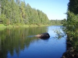
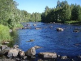
River Kuivajoki is a mid-sized lowland boreal river, with 970 km2 catchment area. The river is 46 km long and descends 89 metres from Lake Oijärvi to Bothnian Bay, northern part of the Baltic Sea. The mean discharge at the site is 12.8 m³/s. In this section the Kuvajoki is a 4th order stream and is assigned to the fish region salmon-European bullhead. The river is included in the Salmon Action Plan by International Baltic Sea Fishery Commission aiming to re-establish wild salmon population in the river. Kuivajoki is protected from hydropower construction by the Finnish Act on the protection of rapids.
Drivers and pressures
Fast-flowing riffle sections in the Kuivajoki river, as in most other Finnish rivers, were channelized to facilitate timber transport and for flood protection in the early 1900's. Channelisation included removing boulders from the channel which lead to loss of habitats and decreased heterogenity in stream flow patterns. These boulders were placed along the river banks where they are still present. Last timber was transported in the Kuivajoki river in 1954. Furthermore, water quality of the river is deteriorated due to human activities in the catchment. The main pressures in are peat mining, forestry and agriculture and municipal point sources.
Measures selection
Restoration of channelised riffle sections started in Finland in the 1970's. Since then, in total 2000 riffles and 1000 breeding sites have been restored. In the Kuivajoki river, altogether about 5 km of the river (consisting of multiple riffle sections in the river) were restored in the early 2000's. The stream bottom was rearranged using boulders which were removed from the channel and placed along stream margins during channelization. Also gravel beds were created to provide nursery habitat for salmonids. Hirvaskoski is one of these riffle sections in Kuivajoki river where restoration measures were conducted. Riffles in the upper part of Kuivajoki river are still channelized. The funding for the restorations came from regional water boards.
Also the regulation of Lake Oijärvi has been developed to prevent the drying of the natural stream in the upper parts of the Kuivajoki river and to enable the migration of fish throughout the year.
Success criteria
The objectives were to restore natural current conditions and morphology of the stream and to enable breeding and migration of salmonid fish.
Ecological response
Periphyton indicated a good ecological status in 2006-2012 (EQR 0,67).
Fish: Electrofishing was conducted at 13 sites in 2003 after restoration. Both salmon (Salmo salar, frequency 10/13) and grayling (Thymallus thymallus, frequency 7/13) were caught. However, all salmon individuals were older than one year and the age class 0+ was missing, indicating that natural breeding may not happen. The catch had also perch (Perca fluviatilis, frequency 9/13) and roach (Rutilus rutilus, frequency 4/13). In summary, fish indicated a good ecolgoical status in 2003, similar to electrofishing results from previous and the following years (1999-2009).
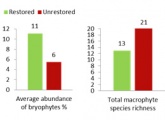
Macrophytes: Especially bryophyte abundance was higher in the restored section (see figure below), which are important for the functioning of boreal streams because they provide habitats for other biota, trap sediment and serve as a feeding area for aquatic insects. However, total species richness of macrophytes was lower in the restored section.
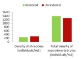
Macroinvertebrates showed no clear differences between the restored and unrestored sections (see figure below). However, the ecological status of the restored section changed from good ecological status in 2006 to an even high ecological status (EQR = 0.843) in 2009 and 2012. Since similar data before restoration are missing for the degraded control section, it is difficult to assess if this positive change in the restored section is due to restoration or an overall trend in the river or catchment (e.g. due to improved water quality). This stresses the need for a full BACI monitoring design (Before-After-Control-Impact). However, since water quality did not improve and rather slightly worsened (see paragraph on water quality below), this might indeed have been a positive effect of restoration.
After restoration (2000-2006) total phosphorus concentration, minimum pH and total nitrogen indicated good status. In the period of 2006-2012 water quality slightly worsened and total phosphorus indicated a moderate status, whereas minimum pH and nitrogen still indicated a good chemical status. Water quality is probably degraded by the eight peat mining areas and a wastewater treatment plant in the catchment.
Hydromorphological response
The effect of the restoration on hydromorphology was assessed at different spatial scales by comparing the restored reach to a nearby degraded reach. The restored site was spatially more diverse in resepct to micro- and mesoscale habitat diversity: the restored site had a higher substrate, flow and depth diversity. At the reach scale, the restored reach had more natural flow patterns, channel geometry and connectivity.
Monitoring before and after implementation of the project
The restored and a still degraded control reach were monitored after restoration (space-for-time substitution). There were no data available prior to restoration for a full BACI monitoring approach (Before-After-Control-Impact).
Socio-economic aspects
No information on socio-economic aspects.
Contact person within the organization
Finnish Environmental Institute, Freshwater Centre Jukka Aroviita E-mail: jukka.aroviita@ymparisto.fi
Extra background information
References
Aronsuu K. & Isid D. 2010. Pohjois-Pohjanmaan jokien hydrologis-morfologiset muutokset sekä mahdolliset hydrologiaan ja morfologiaan vaikuttavat toimenpiteet jokien ekologisen tilan parantamiseksi, www.ymparisto.fi/oulujoen-iijoenvesienhoitoalue
The Finnish Environmental Information: Hertta database.
Vesien kunnostustyöryhmä. 2012. Vesien kunnostustyöryhmän loppuraportti.
http://www.hare.vn.fi/mAsiakirjojenSelailu.asp?h_iId=16574&a_iId=180254
Related Measures
- Improve water retention
- Add/feed sediment
- Ensure minimum flows
- Establish environmental flows / naturalise flow regimes
- Shallow water courses
- Add sediments
- Initiate natural channel dynamics to promote natural regeneration
- Reduce impact of dredging
- Recreate gravel bar and riffles
- Lower river banks or floodplains to enlarge inundation and flooding
- Other measures


