Difference between revisions of "Odra. Actions for environmental restoration and flood control in the lower basin of the Odra River (Burgos)"
From REFORM wiki
(→Site description) |
(→Measures selection) |
||
| Line 15: | Line 15: | ||
==Measures selection== | ==Measures selection== | ||
| + | The project aimed to compensate the flood protection constructions by improving and creating the riparian vegetation.<br /> | ||
| + | the measures include: | ||
| + | :*Removal of sediments and waste from the river channel<br /> | ||
| + | :*Silvicultural treatments (sowing and plantation of native species)<br /> | ||
| + | :*Morphological recovery at some channel reaches<br /> | ||
==Success criteria== | ==Success criteria== | ||
Revision as of 17:29, 9 April 2010
Odra. Actions for environmental restoration and flood control in the lower basin of the Odra River (Burgos)
Key features of the case study
Site description
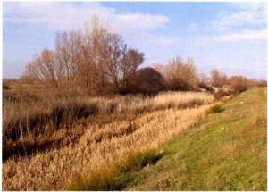
The agricultural development of the last decades has modified the Odra fluvial system so deeply, consequently the river planform has changed, also loosing part of its lateral functionality due to the construction of lateral levees, resulting in lower inundability of the floodplain and invasion of the public hydraulic domain in comparison with a reference state. The disapearance of the riparian corridor makes easier the flooding frequency, even though the high flows are not necessarily too high.
Measures selection
The project aimed to compensate the flood protection constructions by improving and creating the riparian vegetation.
the measures include:
- Removal of sediments and waste from the river channel
- Silvicultural treatments (sowing and plantation of native species)
- Morphological recovery at some channel reaches
- Removal of sediments and waste from the river channel
Success criteria
Ecological response
Hydromorphological response
Monitoring before and after implementation of the project
Socio-economic aspects
Contact person within the organization
Extra background information
References

