Difference between revisions of "Gameren"
(→References) |
(→Introduction) |
||
| Line 56: | Line 56: | ||
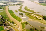
<p>In the period 1995-1999 three secondary channels were excavated in the Gamerensche Waard along the river Waal (the main side branch of the river Rhine). Regarding the dimensions, these channels are unique for Dutch rivers. These channels are digged out partly from former agricultural grassland and partly they ecxists of connected former sand and clay exctraction pits. The three secondary channels vary with regard to location (inside and outside the summer embankment), length (0.5-2 km), width, depth (0-20 m), discharge (1-3%) and the like. Just one of the channels is flowing permanently, the other two | <p>In the period 1995-1999 three secondary channels were excavated in the Gamerensche Waard along the river Waal (the main side branch of the river Rhine). Regarding the dimensions, these channels are unique for Dutch rivers. These channels are digged out partly from former agricultural grassland and partly they ecxists of connected former sand and clay exctraction pits. The three secondary channels vary with regard to location (inside and outside the summer embankment), length (0.5-2 km), width, depth (0-20 m), discharge (1-3%) and the like. Just one of the channels is flowing permanently, the other two | ||
contain flowing water in respectively 4 and 11 months a year.</p> | contain flowing water in respectively 4 and 11 months a year.</p> | ||
| + | |||
| + | ===Results=== | ||
| + | ===Hydrology=== | ||
| + | The monitoring period (1996-2002) was characterized by relatively | ||
| + | high river discharges. Therefore the secondary channels were connected | ||
| + | to the stream flow more frequently than planned. The total discharge | ||
| + | of the three secondary channels is about 2% of the average river | ||
| + | discharge. The maximum flow ve-locity in the secondary channels | ||
| + | appeared at narrows; the strongest turbulences just downstream of | ||
| + | those narrows. With low river discharges, a large influence of navigation | ||
| + | on the flow velocity was visible in the channels; this led sometimes to | ||
| + | a turnover of the flow direction. The discharge capacity of the Waal | ||
| + | with high floods was not lowered significantly by the sedimentation in | ||
| + | the secondary channels. The vegetation development led to only a | ||
| + | minimal decrease of the discharge capacity of the river. | ||
==References== | ==References== | ||
Revision as of 14:41, 7 May 2009
Gameren
Introduction
Under the authority of the Ministry of Transport, Public Works and Water Management (Eastern Netherlands division), the Institute for Inland Water Management and Waste Water Treatment RIZA executed a monitoring program on secondary channels in the Gamerensche Waard. During the period 1996-2002 a broad and complete program was executed with three main objectives: 1) evaluation of the desired effects, 2) assessment of the undesirable side-effects (risks) and 3) increase of the knowledge about secondary channels.
In the period 1995-1999 three secondary channels were excavated in the Gamerensche Waard along the river Waal (the main side branch of the river Rhine). Regarding the dimensions, these channels are unique for Dutch rivers. These channels are digged out partly from former agricultural grassland and partly they ecxists of connected former sand and clay exctraction pits. The three secondary channels vary with regard to location (inside and outside the summer embankment), length (0.5-2 km), width, depth (0-20 m), discharge (1-3%) and the like. Just one of the channels is flowing permanently, the other two contain flowing water in respectively 4 and 11 months a year.
Results
Hydrology
The monitoring period (1996-2002) was characterized by relatively high river discharges. Therefore the secondary channels were connected to the stream flow more frequently than planned. The total discharge of the three secondary channels is about 2% of the average river discharge. The maximum flow ve-locity in the secondary channels appeared at narrows; the strongest turbulences just downstream of those narrows. With low river discharges, a large influence of navigation on the flow velocity was visible in the channels; this led sometimes to a turnover of the flow direction. The discharge capacity of the Waal with high floods was not lowered significantly by the sedimentation in the secondary channels. The vegetation development led to only a minimal decrease of the discharge capacity of the river.
References
File:Evaluatie nevengeulen Gamerensche Waard -.pdf
File:Case study Gameren powerpoint aquatic habitat evaluation.pdf
