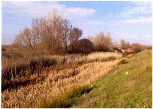
Odra. Actions for environmental restoration and flood control in the lower basin of the Odra River (Burgos)
Odra. Actions for environmental restoration and flood control in the lower basin of the Odra River (Burgos)
Key features of the case study
The agricultural development of the last decades has modified the Odra fluvial system so deeply, consequently the river planform has changed, also loosing part of its lateral functionality due to the construction of lateral levees, resulting in lower inundability of the floodplain and invasion of the public hydraulic domain in comparison with a reference state. The disapearance of the riparian corridor makes easier the flooding frequency, even though the high flows are not necessarily too high.
Site description
The Odra river is tributary of the Pisuerga by its left margin, flowing through the province of Burgos. Traditionally the extensive agricultural of cereal was the predominant land use, replaced by the intensive livestock farming.The fertile floodplain is also used for irrigation crops, including cultivated beetroot, alfalfa, corn and fruit trees.
The original riparian vegetation is now fragmentated, consisting on clumps composed of mediterranean series of willow, poplar and ash tree. At some reaches the riparian forest is in good state of conservation, though.
The channel longitudinal profile is characterised by a series of pools and riffles where the riverbed substrate is composed of sand and gravel in sedimentation areas, and cemented limestone and gypsum in the eroded areas. At constant slope reaches with laminar flow, the longitudinal estructure corresponds to shallow riffles with presence of macrophytes and often braided channel.
A preliminary study[1] showed the presence of Barbus bocagei, Achondrostoma arcasii, Chondrostoma duriense and sporadic
Salmo trutta. Some areas are suitable for cyprinids spawing.
The riparian areas of dense forest coverage are appropriate as semi-aquatic mammals habitat, like Lutra lutraor Mustela vison.
Measures selection
The project aimed to compensate the flood protection constructions by improving and creating the riparian vegetation. The principal aim of the project is to enhance the longitudinal continuity of the riparian corridor, restoring its function of ecological corridor.
The main measures include:
- Removal of sediments and waste from the river channel
- Silvicultural treatments (sowing and plantation of native species)
- Morphological recovery at some channel reaches
- Removal of sediments and waste from the river channel
Other measures are directed to flood protection, and consist in reconstruction and elevation of the banks, sowing to prevent their erosion, and protecting some areas with joint plantings of willow.
Success criteria
Ecological response
Hydromorphological response
Monitoring before and after implementation of the project
Socio-economic aspects
The project has a total budget of 3.071.812,02 €, financed entirely by the Ministry of Environment.
Contact person within the organization
Ignacio Rodríguez Muñóz.
Comisario de Aguas de la Confederación Hidrográfica del Duero.
e-mail: irm@chduero.es
Extra background information
References
- ↑ Morales, J., V. Paredes, A. I. Negro & R. Fernández.Estudio preliminar de las poblaciones de náyades del río Odra (Burgos, previo a las actuaciones de su recuperación ambiental dentro del Plan Nacional de Restauración de Ríos.Ecología, N.º 21, 2007, pp. 107-120
Morales, J., V. Paredes, A. I. Negro & R. Fernández.Estudio preliminar de las poblaciones de náyades del río Odra (Burgos, previo a las actuaciones de su recuperación ambiental dentro del Plan Nacional de Restauración de Ríos.Ecología, N.º 21, 2007, pp. 107-120 [1]
(Preliminary study of tha naiads populations at the Odra river (Burgos), before the environmental recovery actions within the National Strategy for River Restoration)[2]
Dossier of the project.Ministru of the Environment. [http://www.chduero.es/descarga.aspx?fich=/NotasPrensa/Dossier%20ODRA.pdf
]
Factsheet of the project. Ministry of Environment [3]

